BEDA sounded like a GREAT idea until I remembered: The Weekend. I don’t typically make time for blogging on the weekend unless something really exciting happens. Fortunately, I went on a very pleasant hike today, so I actually have something to talk about. And, since the spouse-creature passed out around 5:30 only to be woken briefly for meatloaf dinner before succumbing once again to somnambulism [he was up for 30 hours due to a night shoot for Banshee], I have an evening free. (Tim: I know. Sigh. I know.)
Morgan-Monroe State Forest is home to numerous hiking trails, picnic areas and campgrounds. My parents and I ventured out there last summer and discovered the Scout Ridge Nature Preserve and Trail. This trail starts at the Scout Campground shelter and then winds down into a ravine. This area has very stark hills and valleys (argh, I know I’m using the wrong terminology here, sorry Nancy), in a way that only glaciers could be responsible for. See this pdf for more info on the area.
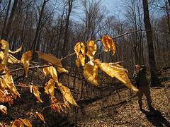
This particular path crosses the stream at least five times. There are a few proper bridges to cross and few ‘maybe this flat-ish rock/wet leaves/slick clay won’t dump me into the water if I leap onto it to get to the other side’ crossings. This is my favorite part of the trail. Climbing down into the ravine is like crawling into the cracks of the earth’s skin. The water runs crystal clear. The smell near the water is clean. The descent is centering. Naturally, I HAD to share this experience.
Tim and I planned to hike this trail for our weekend walk a few weeks ago. He said he enjoyed it, which is a relief considering how much I talked it up. We sat on the last bridge before continuing on the loop that would take us back to the shelter. I could have lie there for a good part of the day, listening to the water and soaking up the sun. Alas, there was Life to be lived, so we crossed the bridge and started the hike out of the ravine to the shelter. The end of this trail isn’t nearly as exciting for me as the beginning and middle. There is a place where the trail seems to go off in one direction, when in fact, it goes on straight ahead (remember this, Mom? Dad?). This trail is subtle. It’s not cleared, so you have to watch for the flattened leaves and places where a chainsaw hacked fallen trees apart to clear the trail.
The trail is .5 miles and is listed as moderate. It seems longer than a half-mile because of the time we took to get down into the ravine and out again. Plus, Tim and I stopped along the way to take many pictures (we both had our Canon Powershots). I only uploaded one picture from this trip onto Flickr. I’ll try to get more up later this week (and pics from Saint Louis).
